In stock KSP I found myself flitting back and fourth between map view and the external view of the game in order to check my apoapsis and periapsis during take-off. Also I found the lack of a radar altitude in external view to be a bit of a pain.
This small module adds these missing numbers to the screen so I don’t have to miss the beautiful view of my take-off when I want to know my altitude, apoapsis etc. The numbers added are as follows…
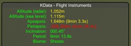
Altitude (radar) – number of meters to the terrain goes red below 1000M, yellow in atmosphere
Altitude (sea level) – regular altitude in meters yellow in atmosphere otherwise green
Apoapsis – Height (and time to reach) your AP in meters, goes cyan if orbit is a circle, yellow in atmosphere, red if below ground
Periapsis – Height (and time to reach) your PE in meters, goes cyan if orbit is a circle, yellow in atmosphere, red if below ground
Inclination – your inclination in degrees and parts thereof
Period – your orbital period, handy when you’re trying to get geostationary orbits setup, goes cyan if a whole or partial geosyncronous orbit along with an indicator to show you which
Biome – The name of the biome you are currently in/over
I mostly wrote this for myself, but I figure others may like it. The source code is hosted over on google code if anyone wants it.